Introduction
Driving in cities varies according to each cities geography, social layout, and hot spots. The traffic issues have a major impact on how a city manages its transportation issues, and that is why public transport systems don't cover the needs of the many. This is why rideshare has become so popular since it provides a personalized solution to a time old problem; how do I get from where I am to where I want to be? So here at RSF, I decided to start preparing guides for my readers, comprehensive insights into anything and everything rideshare related.
RSF City Guides for Drivers
This series will look at specific cities and focus on issues that are related to each and every city. Take into account that all information provided will change over time. Cities tend to change their transportation routes, and business, as well as social locations, move around.
Albuquerque, New Mexico
Albuquerque has a population of around 560,000 and ranks as the 32nd-largest city in the U.S. The Albuquerque metropolitan area has a population of around 910,000 people. The city is located 1,619 meters (1 mile) high and as such has high altitude weather conditions.
Due to Albuquerque elevation, visitors to the town that suffer from asthma, altitude sickness, and heart problems should be aware of the issues of riding in this city. As a driver I suggest you notice whether your passenger suffers from one of the following ailments:
- Fatigue
- Shortness of Breath
- Loss of appetite
Make sure you have plenty water in your car, it helps to relieve some of these issues and keep locations of clinics available to help passengers that suffer seriously.
Another part of the daily climate are flash thunderstorms; they come on quickly drenching everything and everyone and then dissipate. So, keep an umbrella around.
Weekdays
- Morning rush hour: Mon - Fri 7 - 11am
- Evening rush hour: Mon - Thu 3 - 7pm
Weekends
- Fri 3pm - Sat 3am
- Sat 5pm - Sun 3am
The 11 Best Places for Bar Food in Albuquerque
- Geckos Bar & Tapas, 3500 Central Ave SE (at Carlisle Blvd.).
- Two Fools Tavern, 3211 Central Ave NE (btw Wellesly and Bryn Mawr).
- Alien Brew Pub, 6601 Uptown Blvd NE (Louisiana).
- Tractor Brewery Pub, 118 Tulane Dr. SE.
- Billy's Long Bar, 4800 San Mateo Blvd NE (North of Montgomery on San Mateo).
- Ponderosa Brewing Company, 1761 Bellamah NW.
- Spectators-Sports Bar & Grill, 5850 Eubank Blvd NE #59.
- Horse and Angel Tavern, 5809 Juan Tabo Blvd NE (Juan Tabo).
- La Cumbre Brewing Company, 3313 Girard Blvd NE.
- Marble Brewery, 111 Marble Ave NW (at 1st St NW).
- Sidetrack Brewing Company, 413 2nd St SW (Lead And 2nd).
Navigational Aids
Central Ave is a five to six mile stretch with quite a few dilapidated hotels and other buildings. If you are working the night shift, especially on the weekends, don't turn north or south into the area of town between Eubank and Wyoming. This area is known as the "War Zone" it is claimed to be riddled with gang violence. I know that rideshare drivers should not avoid any request, but I strongly suggest you avoid this area all together if possible.
Commuting from Rio Rancho / Corrales and anywhere east of the Rio Grande is a major problem in Albuquerque. This is because all the modern housing projects have been built in those areas, creating massive population overloads in one area. This leads to congestion and standstill traffic during rush hours from 8:30AM and 5:30PM on weekdays
Rush hour will hit you, and you will be stuck in traffic for 2 hours if you work in the following areas:
- Sandia
- Kirtland AFB
- UNM
- downtown
- uptown
- Presbyterian and Lovelace hospitals
Most other commutes in the city are between 0 and 15 minutes.
Interstates (source https://www.aaroads.com/new-mexico/albuquerque/)
25 Pan American Freeway
The 25 joins the Sandoval County cities of Bernalillo and Rio Rancho with Albuquerque and South Valley as the main north-south route.
40 Coronado Freeway
40 (Coronado Freeway) crosses the city of Albuquerque from west Bernalillo County and the Laguna Indian Reservation to Cibola National Forest and Tijeras.
U.S. highways
U.S. 550
This is Albuquerque's only U.S. highway and covers the Albuquerque metropolitan area. It ends urban interchange (Exit 242) with Interstate 25, opposite with New Mexico 165 in Bernalillo.
State Highways
New Mexico 45 – Coors Boulevard
Following Coors Boulevard northward, New Mexico 45 travels from South Valley to Arenal and west Albuquerque, ending at Central Avenue.
New Mexico 47 – Broadway Blvd / Candelaria Rd / 2nd St
The 47 follows Broadway Boulevard north from South Valley through Downtown to Candelaria Road where it turns west. Candelaria Road returns the route to 2nd Street, which leads north to Alameda and the New Mexico 47 terminus at 4th Street (New Mexico 556 south).
New Mexico 313
This 33 goes 17 miles north from New Mexico 556 (Roy Avenue) to Bernalillo through Santa Ana Pueblo.
New Mexico 315
The 315 is a short connector between Interstate 25 at Exit 248 and New Mexico 313, serving the Algodones area within the San Felipe Indian Reservation.
New Mexico 333
The 333 is parallel to Interstate 40 east from Albuquerque to Camuel and Tijeras, on a 28-mile routing. The 333 begins at the Central Avenue intersection with New Mexico 556 (Tramway Boulevard) adjacent to Interstate 40 at Exit 167.
New Mexico 345 – Unser Boulevard
The 345 overlays approximately 4 miles of Unser Boulevard, a long north-south arterial that joins the Bernalillo west suburbs with Rio Rancho in Sandoval County. The route begins at Central Avenue and ends at St. Joseph's Avenue.
New Mexico 423 – Paseo Del Norte
Albuquerque's only non-Interstate freeway, New Mexico 423 (Paseo Del Norte Boulevard), gives fast travel between Jefferson Street (North Valley) and Eagle Ranch Road (Paradise Hills). This is a 17-mile route between New Mexico 556 (Tramway Boulevard) and Golf Course Road. The non-freeway portion consists of a busy surface arterial east to North Albuquerque Acres. A western extension carries Paseo Del Norte beyond the state highway end to Atrisco Vista Boulevard.
New Mexico 448 – Coors Boulevard
The 448 is a 13mile route that loops east from New Mexico 528 through Corrales to Coors Boulevard in Albuquerque. The state route follows all of Coors southward to a truncated end at St. Joseph's Avenue.
New Mexico 473
The 473 is a short connector between Interstate 25 at Exit 240 and New Mexico 313 in Bernalillo.
New Mexico 500 – Atrisco Vista Blvd / Rio Bravo Blvd
The 500 is a four-lane divided arterial that follows Rio Bravo Boulevard, and travels just over 4miles east-west between New Mexico 45 (Coors Boulevard) and Interstate 25 at Exit 220.
New Mexico 528 – Alameda Blvd / Pat D'Arco Hwy
The 528 is a 15.4-mile loop west from Interstate 25 through Rio Rancho and north Albuquerque. The state highway begins at Exit 233 and follows Alameda Boulevard west to the Coors Bypass north of Cottonwood Mall. Pat D'Arco Highawy continues the route northward through Sandoval County to U.S. 550.
New Mexico 556 – Tramway Road / Boulevard
The 556 takes Tramway Boulevard / Road north from Foot Hills Road and Interstate 40 at Exit 167 around the northeast side of Albuquerque to the Roy Avenue extension at Interstate 25 (Exit 234). The 556's west end lies at the 2nd Street (New Mexico 47) split from 4th Street.
A few pointers about Coal Avenue East
- Eastbound Coal Avenue at 5th Street. Coal Avenue is one of several streets named after metals. Others include Iron, Lead, Silver, Gold, and Copper. 4th Street crosses Coal Avenue in this scene.
- Coal Avenue switches to one-way street eastbound beyond 2nd Street. 2nd Street leads north into the Arts and Entertainment District of Downtown Albuquerque.
- A three-lane viaduct carries Coal Avenue eastward over 1st Street and the BNSF/Amtrak railroad lines between 2nd Street and Broadway.
- Coal Avenue touches down at Broadway (New Mexico 47). New Mexico 47 travels Broadway from South Valley to Candelaria Road.
- Entering the intersection with Locust Street at the southbound on-ramp to Interstate 25. A split diamond interchange joins the freeway with Coal Avenue east and Lead Avenue west
- Oak Street represents New Mexico Frontage Road 2523 heading north from Exit 224A. Coal Avenue continues beyond the freeway east to Roosevelt Park.
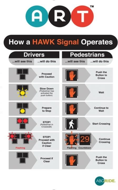
Driving With ART
Albuquerque Rapid Transit (ART) was developed to enable both drivers and pedestrians a safe environment to flow when interacting. The system integrated HAWK traffic lights that notify drivers when pedestrians are about to cross and are meant to assure pedestrians that drivers will know when to stop.
Chief Operations Officer for the City of Albuquerque, Michael Riordan explains: "The prime objective of a HAWK signal is to provide pedestrians with safe crossing opportunities, and with the ability to balance the needs of the pedestrians with driver delay. This is a valuable component of the HAWK treatment. We believe these signals will help reduce pedestrian crashes."
Drivers will notice along the ART roadway, pavement markings and traffic signals that will indicate where and when it's safe for drivers to turn.
Left turns, and U-Turns are still permitted on Central, only at signalized intersections.
At 41 signalized locations along the ART corridor (outside of Downtown Albuquerque), drivers will be able to make not only protected left turns but also protected U-turns.
Another entitlement for drivers on the ART route is that they can take a protected left turn/U-turn when they have the light, even if the ART bus is at the station. The drivers themselves will have their own set of signals.
The ART dedicated lanes cover 90 percent of Central from Louisiana to Coors. Are painted with Red, called the red lanes are for public transport only. That means buses and emergency vehicles only.
41 Signalized Intersections along the ART Route:
- Coors
- 63rd
- 59th
- Yucca
- 52nd
- 47th
- El Super parking lot
- Atrisco
- Sunset
- Tingley
- New York
- Rio Grande
- San Pasquale
- Laguna
- 14th
- 12th
- 10th
- Broadway
- Edith
- High
- Locust
- Oak
- Mulberry
- Spruce
- University
- Yale
- Cornell
- Stanford
- Princeton
- Girard
- Richmond
- Wellesley
- Carlisle
- Morningside
- Washington
- Monroe
- San Mateo
- Alvarado
- San Pedro
- Expo NM
- Louisiana
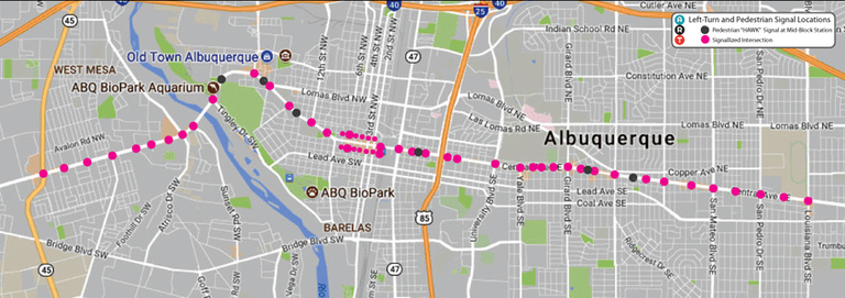
A map of the 41 Signalized Intersection along Central Avenue